We specialize in Drone Solutions & Survey
At AtomGeo Survey Solutions, we specialize in delivering comprehensive and accurate geospatial survey capabilities. Our advanced technologies, including drone surveys, 3D laser scanning, and mobile mapping, enable us to capture precise data for a wide range of projects.
From large-scale land mapping to infrastructure inspections and environmental assessments, our capabilities empower informed decision-making. With our skilled team of experts, cutting-edge equipment, and efficient data processing,
we provide actionable insights for industries such as construction, urban planning, and natural resource management. Partner with us to unlock the full potential of geospatial surveying and gain a competitive edge in your projects.
Drones Surveys
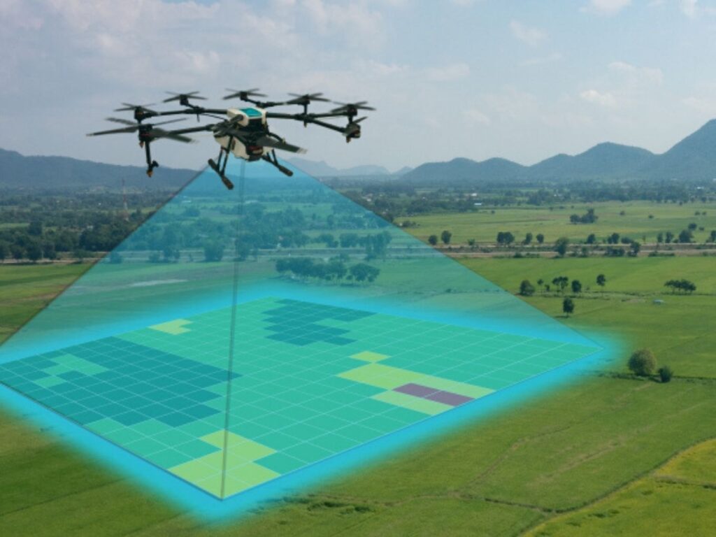
AtomGeo Private Limited takes aerial surveying to new heights with our advanced drone survey capabilities. We leverage the latest drone technology and a team of skilled drone pilots to provide efficient and accurate data collection for a wide range of geospatial projects.
Equipped with high-resolution cameras and sensors, our fleet of drones allows us to capture detailed imagery and geospatial data from unique vantage points. From large-scale land mapping to infrastructure inspections and environmental monitoring, our drone surveys offer a cost-effective and versatile solution.
Our experienced drone pilots navigate the drones with precision, ensuring optimal coverage and capturing the necessary data for your project. They are trained to operate in compliance with safety regulations, ensuring a safe and efficient surveying process.
The data collected through our drone surveys is processed and analyzed by our team of geospatial experts. Using advanced photogrammetry and data processing techniques, we generate accurate 3D models, orthomosaic maps, and point clouds that provide valuable insights for your specific needs.
By employing drone technology, we eliminate the limitations of traditional surveying methods, enabling faster data acquisition, increased safety, and access to remote or inaccessible areas. Our drone survey capabilities are ideal for applications such as land surveying, construction site monitoring, environmental assessments, and infrastructure planning.
Partnering with AtomGeo for your drone survey requirements means benefiting from our expertise in aerial data collection and analysis. We deliver high-quality, actionable geospatial information that empowers you to make informed decisions for your projects.
Experience the advantages of drone survey capabilities with AtomGeo Private Limited. Contact us today to discuss how we can integrate drone technology into your geospatial projects and unlock new perspectives in data collection and analysis.
3D Laser Scanning Block
3D Laser Scanning Capabilities:
At AtomGeo Private Limited, we harness the cutting-edge technology of 3D laser scanning to capture highly detailed and accurate representations of the physical world. Our advanced scanning equipment and skilled team enable us to provide comprehensive 3D scanning services that meet the diverse needs of our clients.
With our 3D laser scanning capabilities, we can capture and digitize complex environments, structures, and objects with unparalleled precision. Our scanners use laser beams to rapidly measure millions of data points, creating a detailed point cloud that accurately represents the geometry and characteristics of the scanned area.
Whether it’s architectural structures, industrial facilities, archaeological sites, or natural landscapes, our 3D laser scanning solutions offer a wealth of benefits. We can provide precise measurements, detailed visualizations, and valuable insights for various applications, including design and planning, facility management, heritage preservation, and construction monitoring.
Our skilled team of experts ensures that every scanning project is executed efficiently and effectively. We meticulously process and analyze the collected data, transforming it into actionable information and customizable deliverables that suit our clients’ specific requirements.
Partner with AtomGeo Private Limited for your 3D laser scanning needs, and unlock a new dimension of accuracy and detail. Experience the power of our advanced technology and expert team, delivering top-notch solutions for your most complex spatial challenges.
Mobile Mapping
AtomGeo Private Limited offers state-of-the-art mobile mapping survey capabilities that revolutionize the way we collect and analyze geospatial data. Our advanced mobile mapping solutions combine the power of cutting-edge technologies with our skilled team’s expertise to deliver comprehensive and accurate survey results.
Using specialized vehicles equipped with an array of sensors, including LiDAR, GPS, and high-resolution cameras, we can efficiently capture precise geospatial
information while covering large areas. Our mobile mapping systems collect data in real-time, allowing for rapid and cost-effective data acquisition.
With our mobile mapping survey capabilities, we can accurately capture 3D geometry, detailed imagery, and precise location information of roads, highways, urban areas, and infrastructure networks. This data serves as a foundation for various applications, such as transportation planning, asset management, city mapping, and infrastructure development.
Our experienced team of surveyors and geospatial experts meticulously process and analyze the collected data, ensuring the highest level of accuracy and quality. Through advanced data processing techniques, we transform raw data into valuable insights, visualizations, and customizable deliverables tailored to meet our clients’ specific needs.
Partnering with AtomGeo for your mobile mapping survey needs ensures that you receive comprehensive and reliable geospatial data that drives informed decision making. Our cutting-edge technology, coupled with our skilled team’s expertise, guarantees accurate and efficient data collection, processing, and analysis.
Experience the power of mobile mapping survey capabilities with AtomGeo Private Limited and unlock a new level of precision in your geospatial projects. Contact us today to discuss how we can assist you in leveraging this advanced technology for your specific requirements.